News
- I am now at South China Agricultural University (SCAU).
- MSc/PhD students and Postdocs are welcome to join my group (details).
- G-Cubed: Continuous subsidence of Dallol volcano from InSAR
- GRL: The 2024 Fentale diking episode from InSAR and Seismicity
- IEEE TGRS: TRAFAC - Tikhonov Regularization And Flux Analysis Corrector for Phase Unwrapping
- IJAEOG: Model-assisted phase unwrapping for InSAR mining subsidence monitoring
- NatCom: Simultaneous rift-scale inflation of a deep crustal sill network in Afar
Research Interests
| I develop advanced InSAR/GNSS algorithm to extract accurate surface deformation signal. The major products include Pi-RATE for InSAR rate and time series estimation, and X2V for accurate velocity estimation from GNSS position time series. | |
| I develop advanced algorithms for forward and inverse computing of deformation. All the algorithms are integrated as the DISLOC package, which calculates deformation using Mogi (Mogi 1958) and Okada (Okada 1985, 1992) models. InSAR, GNSS and offset tracking data are supported in the package. | |
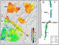 | I use InSAR and GNSS to observe and model crustal deformation associated with all phases of the seismic cycle, including coseismic strain release, interseimic strain accumulation, aseismic creep, and postseismic relaxation. The best advantage of geodesy over other techniques is its capability to capture surface deformation at mm-level accuracy over the entire lifetime of earthquakes, thus providing us opportunities to understand the seismogenic mechanisms. |
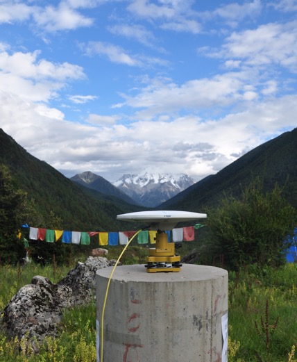
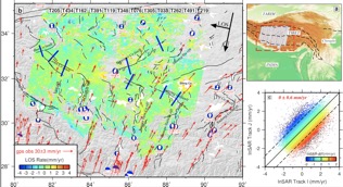
 | I use GNSS data to study continental-scale crustal deformation, particularly in the India-Eurasia collision zone. My current work focuses on GNSS processing for the China Seismic Experimental Site (CSES), which is an exciting place for geoscientists considering its complex tectonics, frequent large earthquakes and dense observations. I have developed a preliminary deformation model for the CSES mainly based on GNSS data collected over the last two decades. |
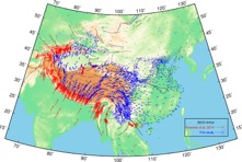
 | I develop algorithm to determine large-scale crustal velocity and strain rate field using InSAR and GNSS. Because of the high-spatial resolution of InSAR and its comparable accuracy with GNSS, the velocity field usually shows much more details than those from GNSS alone. The novel approach was firstly used in western Tibet, and then it was used in Afar, central-south Tibet and Turkey. The ESA's Sentinel-1 twin satellites make our VELMAP approach more promising to determine the next generation of global-scale velocity field. |
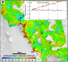 | I use InSAR to measure land subsidence in urban areas. Behaving with high spatial resolution, high accuracy and large archive of historical imagery, InSAR is the best mean to map large-scale urban deformation. I developed a novel approach to combine multi-track, multi-satellite data. This enables us to improve the accuracy and the temporal resolution of InSAR time series products. With the multi-track approach, we identified a long coastal subsidence zone for the first time in the Pearl River Delta. |
 | I use InSAR to measure mining subsidence. The large coverage of satellite radar imagery enables InSAR to monitor tens or even hundreds of mines all together within one standard frame. Hence InSAR is unique to monitor illegal mining activities and ensure safety during mining progress. Currently we focus on solving problems due to large-gradient deformation, which usually causes loss of coherence, fringes mixture and non-linear subsidence in time. |
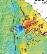 | I use InSAR and GNSS to study the rift episodes in the Afar depression in collaboration with some outstanding scientists. Afar and Iceland are the only two regions of the mid-ocean ridge system located on land. It's exciting to witness the undergoing tectonic activities in these regions with direct satellite geodetic observations. We determine the deformation pattern in Afar to understand how extension, faulting and magmatism control the rifting progress, and how crustal extension is transferred from one rift segment to another. |
I am a professor of geodesy at South China Agricultural University, China. I am interested in developing InSAR and GNSS algorithms, and using satellite geodesy to investigate crustal deformation, land subsidence and other geophysical progresses.
Contact
Prof. Hua Wang
College of Natural Resources and Environment
South China Agricultural University
483 Wushan Rd., Tianhe District
Guangzhou, 510642, China
E-mail: ehwang -at- 163 dot com